Charted Obstacles and Airport Complexity Facts
Where charted obstacles and airport airspace facts show up in your briefing, what the FAA Digital Obstacle File lists and leaves out, how to read the accuracy codes, and which airspace facts PlaneWX prints for an airport. Both sets of rows show facts only.
Display only
Charted obstacle rows and airport complexity facts are display only. They add 0 WX Score (briefing) points and 0 FRAT points. The WX Score and the FRAT total are the same with these rows shown or hidden.
Where you see it in the briefing
Charted obstacles and airport airspace facts show up in four places in a briefing: the route map, the Gotchas card, the Departure and Arrival cards, and the route strip under those cards. None of the four changes the WX Score or the FRAT.
1. Route map: the Charted obstacles layer
- Tap the route map, or Expand at its lower right, to open the full map. Obstacle pins are on the full map only, not on the small map in the briefing.
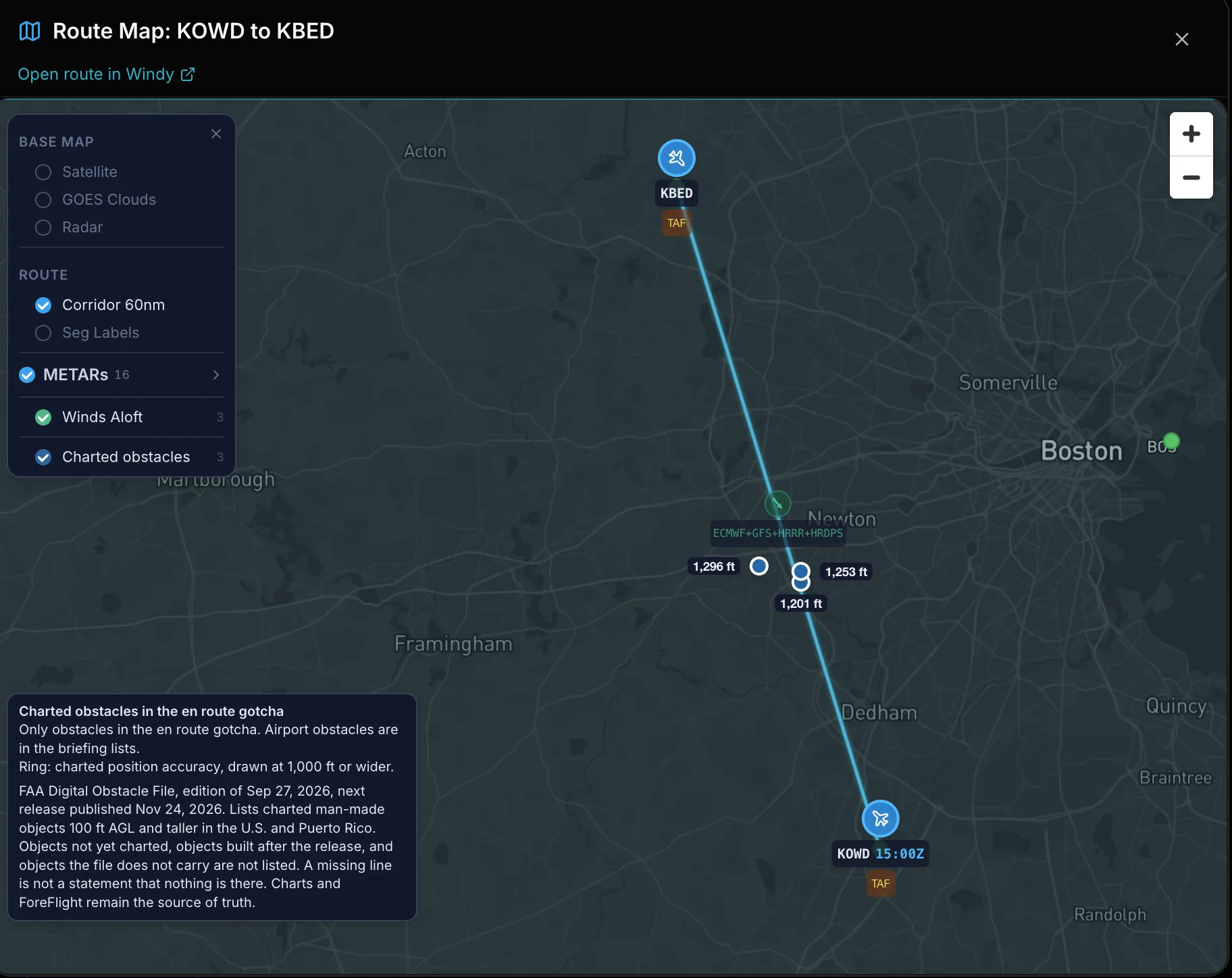
- Open the layer list with the layers button at the top left of the map. The Charted obstacles row, below the route hazards, turns the pins on and off and shows how many are plotted. The layer starts on.
- Each pin sits on the charted position and carries the height above ground in ft. Tap a pin for its line: type, height in ft AGL, top in ft MSL, where it sits along the route, lighting, and the FAA accuracy.
- The pins are the obstacles in the en route gotcha (place 2 below). Obstacles near the departure and arrival airports are listed in the airport cards (place 3), not on the map. When the en route gotcha has no obstacle, the map has no obstacle layer.
- The legend box sits at the lower left of the map. On a phone it starts closed as an Obstacle legend button, and Hide legend closes it again. It prints, in order:
- Charted obstacles in the en route gotcha
- Only obstacles in the en route gotcha. Airport obstacles are in the briefing lists.
- Ring: charted position accuracy, drawn at 1,000 ft or wider.
- Position accuracy not charted: no ring. (only when a pin has no charted position accuracy)
- The coverage line: the FAA Digital Obstacle File edition in use and the date the next release is published, charted man-made objects 100 ft AGL and taller in the U.S. and Puerto Rico, and what the file leaves out. It ends with: Charts and ForeFlight remain the source of truth.
- A ring shows how far the charted position can be off, from the FAA horizontal accuracy code. The ring is the charted accuracy only. It is not a promise that nothing else is there.
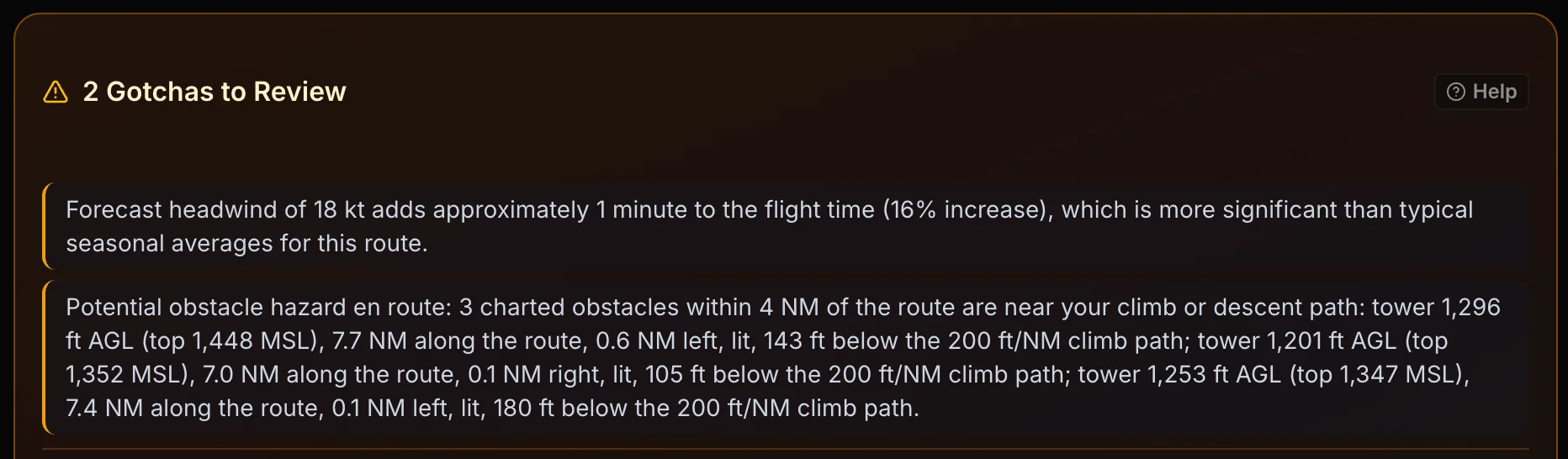
2. Gotchas: Potential obstacle hazard en route
The Gotchas card can carry one obstacle line. It starts with Potential obstacle hazard en route and counts the charted obstacles within 4 NM of the route that meet these checks:
- Climb and descent at every planned altitude, plus the cruise phase of the trip: a cruise-phase obstacle is listed when it sticks up to within 1,000 ft of your planned altitude or higher (2,000 ft over a mountainous segment), and one lower than that is not. With no planned altitude, and when the route length and both field elevations are known, the whole route counts as climb or descent. When they are not known, or for a local flight, the climb and descent check does not run and the card says so.
- Climb and descent: past the 5 NM rings around the departure and arrival, until the climb or descent meets your planned altitude, the top is within 200 ft of a 200 ft/NM climb path or a 3 degree descent path, or higher. This check runs when the route length and both field elevations are known. When they are not known, the cruise check applies instead: the top is within 1,000 ft of your planned altitude or higher (2,000 ft over a mountainous segment).
- Inside 5 NM of the departure and arrival airports, the airport checks apply instead (place 3).
- The FAA height accuracy is added to each top when the code is charted. When it is not charted, 1,000 ft is assumed and the line says so. An obstacle with no charted top is listed with height unknown, and only when it lies in the climb or descent part of the route.
- For a local flight, the check is a top within 500 ft of your planned minimum altitude or higher.
The line lists up to 3 obstacles, then +N more. Each listed obstacle shows:
- Type, height in ft AGL and top in ft MSL.
- Distance along the route in NM.
- Side: NM left or right of the route line, or on the route line.
- Lit or not lit, when the FAA file gives the lighting.
- How far the top is below or above your altitude, or below or above the 200 ft/NM climb path or the 3 degree descent path.
- Mountainous segment, when the wider band applied, and the height accuracy.
The line is plain text. The obstacles it lists are the pins on the route map. Obstacles near the airports are not in Gotchas.
3. Departure and Arrival cards
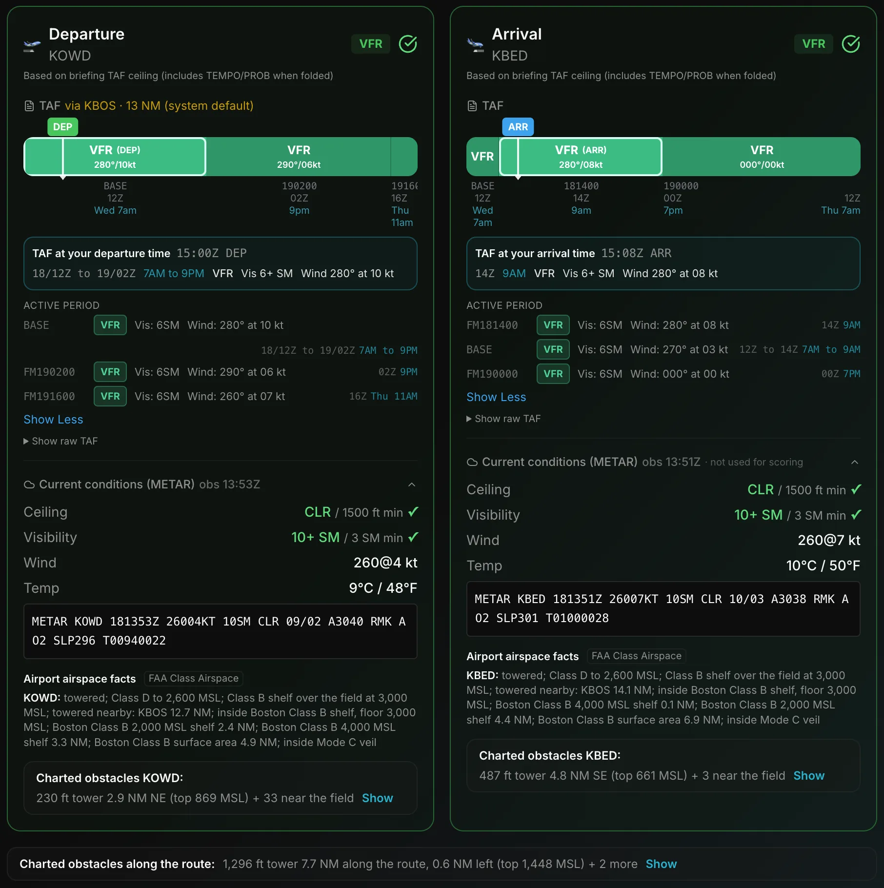
In the Terminal Weather section, each airport card ends with two rows below the weather: Airport airspace facts, then Charted obstacles with the airport identifier.
Airport airspace facts
- The row title is Airport airspace facts, tagged FAA Class Airspace. One line starts with the airport identifier.
- The line joins the facts that apply: towered or no tower; the field's own surface area, with a Class D top in ft MSL; a shelf over the field with its floor; towered airports nearby; the nearest Class B surface area or shelf, with the shelf floor in ft MSL and the distance in NM; and inside Mode C veil.
- Tap the line to open each fact in full. The source line prints under the opened facts. Each fact is explained under Airport complexity facts below.
- When the departure and arrival are the same airport, the row shows once.
Charted obstacles and the airport identifier
- Closed, the row is one line: the lead flagged obstacle with its height in ft AGL, distance and compass direction from the field, and top in ft MSL, then + N near the field when more are flagged.
- Tap Show to list each flagged obstacle on its own line. The checks are explained once under the list, with the FAA source. Tap Source and coverage for the source, the coverage line and the block text with accuracy. Hide closes the list.
- An obstacle near the airport is flagged when its top is within 500 ft of the pattern altitude or higher inside 5 NM of the field, or within 200 ft of a 200 ft/NM climb or 3 degree approach path or higher inside 1.5 NM, within 0.5 NM of an extended runway centerline. The pattern altitude is the published one, else 1,000 ft AGL for a piston and 1,500 ft AGL for a turbine.
- When nothing near the airport is flagged, the card has no obstacle row.
4. Charted obstacles along the route
- Below the Departure and Arrival cards, still in Terminal Weather, the Charted obstacles along the route strip covers the route between the airports.
- Closed, it names the lead flagged obstacle with its height in ft AGL, distance along the route, side and top in ft MSL, then + N more. These are the same obstacles as the en route gotcha and the map pins.
- With nothing flagged by the climb, descent or cruise checks it reads: None flagged within 4 NM of the route. When the trip has no planned altitude and the route length and both field elevations are known, the climb and descent checks still run, and with none flagged it reads: No planned altitude was given: no climb or descent obstacles flagged along the route. When the check cannot run (a missing field elevation or route length, or a local flight), it reads: No planned altitude was given, and the climb and descent check could not run: climb and descent obstacles were not checked. Route obstacles are listed under show all.
- Tap Show to list the flagged ones with the checks, then Show all to list every charted obstacle found along the route. Hide closes the list. The opened list ends with the source, the coverage line and this line: Facts only. These rows add no WX Score (briefing) points and no FRAT points.
The same obstacle and airspace rows also print as read only facts in the FRAT Environment section, beside the existing airport chips. The route row there lists only the flagged route obstacles (the same set as the route card), at every planned altitude, including 18,000 ft and higher. With no planned altitude, and when the route length and both field elevations are known, it lists the climb and descent obstacles and adds this note: No planned altitude was given: showing climb and descent obstacles only. When the check cannot run, the note says the climb and descent obstacles were not checked. The row also keeps the partial coverage line, and it stays when coverage is partial or there is no data, so none flagged can be told apart from no data.
What the list covers
- Source: the FAA Digital Obstacle File (DOF). It lists charted man-made objects such as towers, poles, windmills and buildings.
- Area: the U.S. and Puerto Rico.
- Height: objects 100 ft AGL and taller. Counts on a briefing name the cutoff they use, for example 100 ft AGL and taller or 200 ft AGL and taller.
- Each line prints the DOF object type as the file gives it, for example Tower. The file does not say what a tower carries, so PlaneWX does not either.
- Each line prints height above ground (AGL) and the top in ft MSL. Pressure altitude, density altitude and altimeter setting are not applied to the ft MSL value.
How far the list looks
- Airport card: only the charted obstacles within 5 NM of the field that meet the checks named in the card footnote. If none meet a check, no airport obstacle card is shown.
- An airport card line whose top is 1,000 ft or more above the field elevation ends with: Top 1,000 ft or more above the field.
- Route: objects 200 ft AGL and taller within 4 NM each side of the route are counted.
- Route lines: the lines are the climb and descent obstacles within 4 NM of the route, at every planned altitude, including 18,000 ft and higher. Cruise-phase obstacles are added when their top is within 1,000 ft of your planned altitude or higher. Show all lists every charted obstacle.
- Briefings stored before the display filter listed objects within 1,000 ft of the planned altitude or higher, or tops only; those briefings are not recomputed.
What the list does not cover
- The list is not a complete list of obstacles. A line that is missing is not a statement that nothing is there.
- Towers and other objects built after the release are not included. Objects not yet charted, and objects the file does not carry, are not included.
- Objects shorter than 100 ft AGL are not listed.
- Natural features such as terrain and trees are not in the file. Terrain comes from the elevation profile described on Terrain Clearance, and that profile does not include towers, masts or wires.
- Outside the U.S. and Puerto Rico, PlaneWX prints this line: Obstacle data not available for this route. Charts and ForeFlight remain the source of truth.
- PlaneWX shows facts, not a clearance statement. It does not subtract a terrain value from an obstacle height, and it does not state a margin over an obstacle.
- Charts and ForeFlight remain the source of truth.
FAA release cycle: 56 days
The FAA updates the DOF every 56 days. The release in use is Sep 27, 2026. The next FAA release is Nov 24, 2026. Each obstacle block ends with a coverage line that names the release date in use and the next release date. An object charted after that release is not in the block until PlaneWX loads the next release.
FAA disclaimer
Quoted from the FAA Digital Obstacle File ReadMe, caution and note. The wording is the FAA wording.
“The Digital Obstacle File contains only obstruction data for those man-made objects which affect domestic aeronautical charting products and does not purport to indicate the presence of all obstructions which may be encountered.”
“An unverified obstruction is indicated by a “U” in the Verification Status field. This data is considered unreliable because its position and height have not been verified by the ODT. Be cautious when using unverified data.”
Accuracy key
A verified row prints a pair of codes, for example Accuracy 2 / C. The number is the horizontal accuracy and the letter is the vertical accuracy. Accuracy 2 / C reads as position within 50 ft, height within 20 ft. Accuracy 9 or I prints as unknown.
| Number | Meaning |
|---|---|
| 1 | Position within 20 ft |
| 2 | Position within 50 ft |
| 3 | Position within 100 ft |
| 4 | Position within 250 ft |
| 5 | Position within 500 ft |
| 6 | Position within 1,000 ft |
| 7 | Position within 1/2 NM |
| 8 | Position within 1 NM |
| 9 | Position accuracy unknown |
| Letter | Meaning |
|---|---|
| A | Height within 3 ft |
| B | Height within 10 ft |
| C | Height within 20 ft |
| D | Height within 50 ft |
| E | Height within 125 ft |
| F | Height within 250 ft |
| G | Height within 500 ft |
| H | Height within 1,000 ft |
| I | Height accuracy unknown |
Verified and unverified
- Verified rows (O in the file) carry the accuracy codes above and print Verified.
- Unverified rows (U in the file) are shown and print Unverified in the FAA file: position and height not checked by the FAA obstacle team. They print no accuracy pair.
- A few rows list a top in ft MSL that is lower than the height in ft AGL. Those rows print the charted values and the label height values inconsistent in the FAA file.
- A horizontal accuracy of 7 or 8 (1/2 NM or 1 NM) prints with its plain meaning next to the code.
Lighting and marking
Lighting and marking print the charted code only. Lit means the DOF lighting code says lit. It says nothing about whether a light is working at a given time.
| Code | Meaning |
|---|---|
| R | Red |
| D | Medium strobe and red |
| H | High strobe and red |
| M | Medium strobe |
| S | High strobe |
| F | Flood |
| C | Dual medium catenary |
| W | Synchronized red |
| L | Lit, type unknown |
| N | Not lit |
| U | Lighting unknown |
| Code | Meaning |
|---|---|
| P | Painted |
| W | White paint |
| M | Marked |
| F | Flag |
| S | Spherical marker |
| N | Not marked |
| U | Marking unknown |
Airport complexity facts
For an origin or destination, PlaneWX prints airspace facts computed from FAA Class Airspace polygons and the airport record. Each fact is a statement with a distance or an altitude. Facts print in the briefing and in the FRAT Environment section, beside the existing airport chips.
- Tower status. Towered or untowered, as a plain fact.
- Own airspace class. The Class B, C or D surface area that contains the field. If there is none, the line says No Class B, C or D surface area at the field.
- Shelves above the field. A Class B or Class C shelf, or a Class D with a floor above the surface, that lies over the field. The line gives the floor in ft MSL and the gap between the floor and the field elevation.
- Nearby towered airports. Towered airports within 15 NM, measured field to field, closest first, up to 5.
- Abutting airspace. Another surface area that touches the field's own surface area or lies within 1 NM of it. For a field with no surface area, the edges of other surface areas within 10 NM are listed with class, identifier and distance.
- Class B within 10 NM. The distance from the field to the nearest edge of each Class B shelf within 10 NM, with that shelf's floor in ft MSL. When the field sits under a shelf, the gap above the field is printed too.
- Mode C veil. Whether the field is inside the Mode C veil. This is its own fact and does not merge with the Class B distance.
Towered or untowered status never lowers what is shown. Shelves over the field and towered airports within 15 NM print for a field with a tower and for a field without one. Adding Class B data only adds facts and never removes one.
Airspace lines end with the data source and its retrieval date. Charts and ForeFlight remain the source of truth.
Airport complexity facts are display only: 0 WX Score (briefing) points and 0 FRAT points. The existing airport chips and your own Environment self-rate work as described in FRAT Help.