While You're There
Ground weather advisories for the days your aircraft sits parked at your destination. First and foremost, this watches for severe weather — tornadoes, hail, and damaging wind — so you know when it needs to be hangared to survive your trip. It also covers freezing rain, cold-soak preheat guidance, and extreme heat.
Why This Exists
A briefing's WX Score answers "should I fly right now?" But once you land, a different question matters just as much: is my airplane safe sitting on the ramp for the next few days? Hail, gust fronts, tornado watches, and hard freezes don't care whether you're flying — they can damage a parked aircraft just as easily as an airborne one.
"While You're There" answers that second question. It's purely informational — it has no effect on your WX Score, fly / don't-fly status, or any scoring category. It only tells you whether you need a hangar while you're on the ground.
Pro and above — text alerts require Pro Plus
"While You're There" appears automatically on eligible briefings for Pro and above — no setup required. It evaluates U.S. domestic destinations (NWS and SPC don't cover international airports) on flights that aren't a local pattern. Text alerts for new Urgent/Alert ground threats are a Pro Plus benefit under Notifications. For always-on watch at home or between trips, see Ground Protection.
How PlaneWX Knows How Long You're Staying
PlaneWX doesn't ask you to enter a return date. It infers your ground-stay window automatically, in this order, and always tells you which method it used right under the card title:
Multi-leg trip
1. Multi-leg tripIf this leg is part of a multi-leg trip and a later leg departs from this same airport, the window runs until that leg's scheduled departure. "Your next leg to KSAT is scheduled to depart Jul 19."
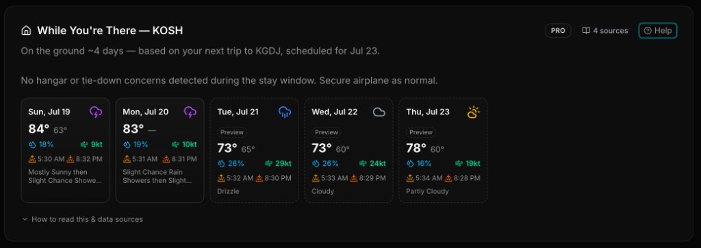
Most PlaneWX pilots plan one leg at a time rather than a single multi-leg itinerary. If you've separately saved a later trip whose origin matches this trip's destination, PlaneWX finds it and uses that departure date instead. "Based on your next trip to KFET, scheduled for Jul 19."
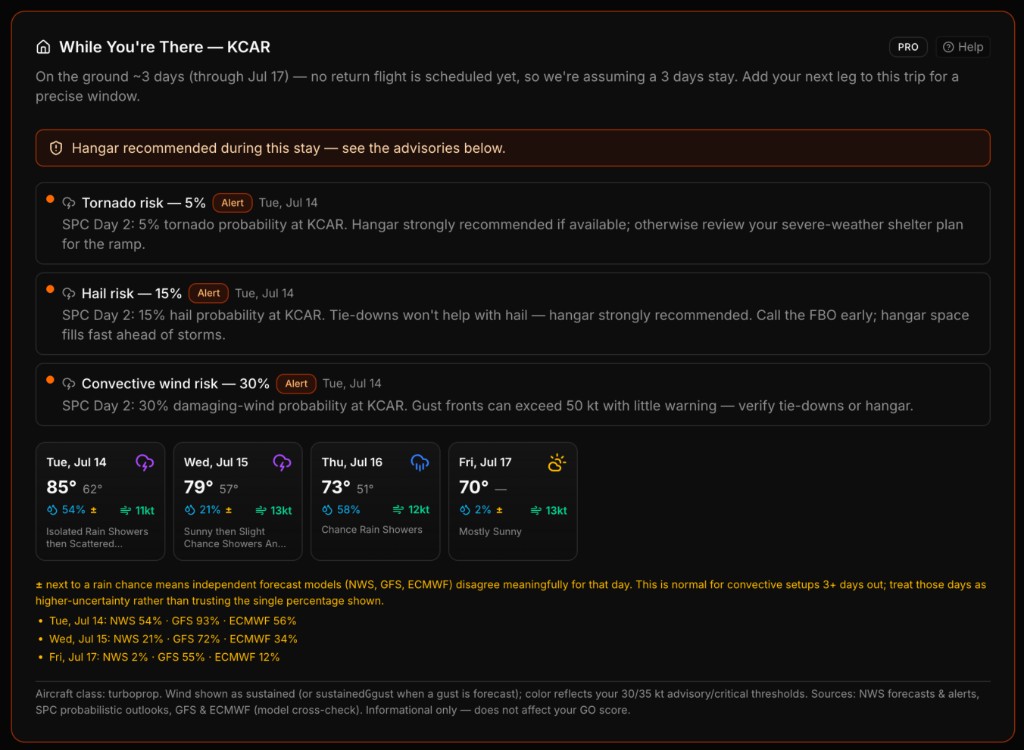
If no follow-on leg exists yet, PlaneWX assumes a 72-hour stay and says so explicitly: "No return flight is scheduled yet, so we're assuming a 3-day stay." Save your return leg as soon as you know it — the window (and the forecast behind it) updates automatically.
For the most accurate result: create your outbound flight — the trip that departs from this destination — as soon as you know its date, even if it's weeks away. That's the only way PlaneWX knows how long your stay actually is; without it, every stay defaults to an assumed 72 hours regardless of your real plans.
Whichever method applies, detailed day-by-day forecast data is capped at 7 days — the practical limit of NWS point forecasts. Longer stays still get their assumption stated, but the daily table only covers the first week.
One nuance: NWS forecasts only look ~7 days ahead from today, not from your arrival date. If you're not landing for another 5-6 days, NWS may not have issued a forecast for most of your stay yet — those days show a dashed-border Preview card (GFS/ECMWF blend, lower confidence) instead of going blank. It's automatically replaced by the real NWS forecast as that day gets closer and you refresh the briefing.
Data Sources
NWS Point Forecast
Day-by-day high/low, precipitation chance, wind, and gusts from api.weather.gov for the exact destination coordinates.
NWS Active Alerts
Live watches, warnings, and advisories that can affect a parked aircraft — tornado, severe thunderstorm, high wind, dust, flood and flash flood (including Flood Watch), winter and ice, fog, smoke, ash, tropical, extreme heat and cold, and related products — filtered by exact NWS event name.
SPC Probabilistic Outlooks
Storm Prediction Center Day 1–3 tornado, hail, and damaging-wind percentages at the destination point.
METAR
Current observed conditions from aviationweather.gov, specifically checked for hail (GR), active thunderstorms (TS/TSRA), and vicinity convection (VCTS). This is the primary catch for “surprise hail” that arrives before any NWS warning or SPC outlook is issued. When the watch airport has no METAR site or no current report, the nearest proxy station is used and labeled in the advisory.
TAF
Terminal Aerodrome Forecast (next ~24–30 h) — scanned for hail (GR) and thunderstorm (TS) groups that overlap your ground-stay window. TEMPO/PROB thunderstorm groups stay advisory-only; only prevailing TS or any GR group triggers an alert SMS. When a Severe Thunderstorm Warning is already active, TAF-TS is silently downgraded to advisory to avoid redundant messages.
GFS & ECMWF Cross-Check
Independent global models compared against the NWS rain chance. When they disagree by a wide margin — common for thunderstorm setups 3+ days out — the day is flagged with a ± so you know to treat that percentage as less certain. Also the source of the local sunrise/sunset times shown on each day card.
All sources are public government/research model data (NOAA, SPC, ECMWF) with no proprietary licensing restrictions — the same reason PlaneWX doesn't use AccuWeather or other black-box commercial providers for this feature.
What Triggers an Advisory
Severe weather is the primary threat this card watches for — the categories below are ordered by how directly they threaten a parked aircraft, starting with the ones most likely to destroy one outright.
Convective (tornado / hail / storms)
Active tornado/severe thunderstorm watches & warnings, plus SPC tornado ≥5%, hail ≥15%, or convective wind ≥15% probability days — the scenario a hangar exists to protect against. METAR hail (GR/TSGR) triggers an Urgent alert even when no NWS warning has been issued yet; a prevailing TAF thunderstorm or TAF GR triggers an Alert. TEMPO or PROB thunderstorm groups without hail stay advisory-only and never send an SMS.
Wind
Forecast sustained wind or gusts exceeding your aircraft's advisory or critical ground-wind threshold (see below). High Wind Warnings/Watches and Extreme Wind Warnings also trigger this.
Regional (hurricane / blizzard / flood)
Other active NWS warnings that threaten a parked aircraft or the field itself — Ice Storm, Hurricane/Tropical Storm, Flash Flood, Blizzard, Dust Storm, and an official Excessive Heat Warning/Watch (distinct from the routine forecast-based Heat advisory below).
Cold
Overnight lows at or below your preheat threshold or POH minimum operating temperature; freezing rain/ice storm; or forecast snow with ≥40% probability. On calm, clear nights near freezing with a tight dewpoint spread, a Frost likely advisory fires — plan wing covers, hangar, or morning deice / preheat.
Heat
Forecast highs of 95°F+ (shade — hangar or sunshades/gust locks — plus avoid topping off fuel on a hot ramp). At 105°F+ this becomes an Alert and does trigger the "Hangar recommended" banner, same as any other Alert — shade is the best mitigation, and a hangar doesn't need to be air-conditioned to help; blocking direct sun is what matters most.
Every advisory is ranked Urgent, Alert, Advisory, or Info. Any Urgent or Alert advisory sets the card's "Hangar recommended" banner — your cue to start calling the FBO before the ramp fills up.
Already Secured a Hangar?
Once you've actually called the FBO and gotten your airplane under a roof, you shouldn't have to keep re-reading the same wind/hail/storm warnings. Click "I have a hangar" (it appears next to the "Hangar recommended" banner, or as a quiet link below the advisory list otherwise) and PlaneWX remembers it for the rest of this stay.
Once toggled on, the card shows a green confirmation instead of the orange banner, and the Wind, Convective, Regional, and Heat advisories a hangar resolves are grayed out and marked Hangared instead of disappearing outright, so you can still see what would have been flagged. Heat texts stop too — the hangar is the action. Click Undo any time (e.g. if your hangar reservation falls through).
Cold advisories stay at full visibility. A hangar doesn't fix a preheat requirement unless it's heated, which PlaneWX has no way to know.
Per-trip and resets for your next stay — it doesn't carry over to future trips to the same airport.
Thresholds Are Aircraft-Specific
A 40-knot gust is a non-event for a PC-12 and a real problem for a 1,320 lb light sport. PlaneWX classifies your aircraft (light sport, single, twin, or turboprop) from its type and applies sensible class defaults — but two fields on your Aircraft Profile override those defaults whenever you've set them:
Max Ground Wind (POH)
Your POH's tie-down/gust limit, in knots. Sets the wind-critical threshold directly; the advisory threshold sits a few knots below it.
Min Operating Temperature (POH)
Many aircraft have an explicit "do not operate below" temperature. Set it once and PlaneWX flags any overnight low that crosses it as an Alert, not just a preheat Advisory.
Haven't set these? PlaneWX falls back to conservative class defaults (e.g. 25/35 kt advisory/critical for light sport, 40/50 kt for turboprops) so the feature still works out of the box.
Important Limitations
- •Never affects your WX Score. This card answers "will my plane be OK on the ramp," not "should I fly." It carries no scoring weight and cannot trigger a 0%.
- •U.S. domestic airports only. NWS and SPC don't cover international destinations, so the card doesn't appear for flights arriving outside the U.S.
- •Refreshes with your briefing and via PlaneWX's hourly ground-weather job. For always-on monitoring with SMS (home / parked between trips), see Ground Protection (Pro Plus).
- •Always confirm hangar availability directly with the FBO — this card tells you when to start calling, not that space is guaranteed.
Have ideas to make this better? Click the Feedback button in the navigation — we read every submission.