Wildfire Smoke
How PlaneWX detects smoke along your route, shows it on the map, and — for VFR flights — scores en-route visibility against your personal minimums.
Why Smoke Matters
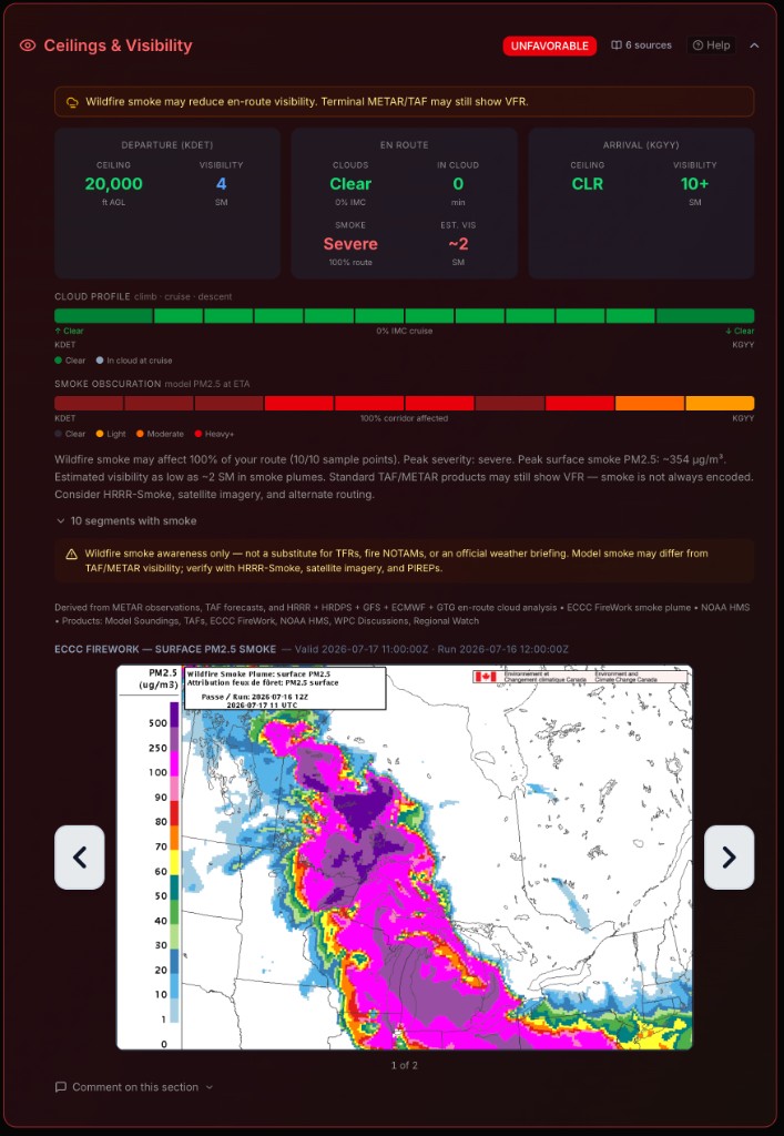
Wildfire smoke can cut surface and low-level visibility for hundreds of miles downwind of the fire. METARs and TAFs at your departure and arrival may still look fine while the corridor between them is in thick haze — especially on longer VFR cross-countries where you need to see the ground and the next waypoint.
PlaneWX samples smoke along your route corridor so you see the problem before you're airborne, not when the horizon disappears mid-leg.
What You'll See in a Briefing
Route map plume overlay
When NOAA HMS detects smoke near your route, a shaded plume appears on the map. Click the plume for density and source details. Corridor sample points along the route show estimated visibility where PM2.5 data is available.
Briefing narrative
Active smoke is called out in the briefing so you know severity, how much of the route is affected, and the lowest estimated visibility along the corridor.
WX Score impact (VFR only)
For VFR flights, en-route smoke visibility is scored against your VFR visibility soft and hard minimums. IFR flights still show smoke for awareness, but smoke alone does not change the WX Score — IFR operations are not visibility-limited the same way.
How VFR Smoke Scoring Works
Smoke scoring looks only at the en-route portion of the corridor — sample points between departure and arrival. Terminal ceiling and visibility at the airports continue to be judged by METARs and TAFs against the same personal minimums, separately.
Hard minimum
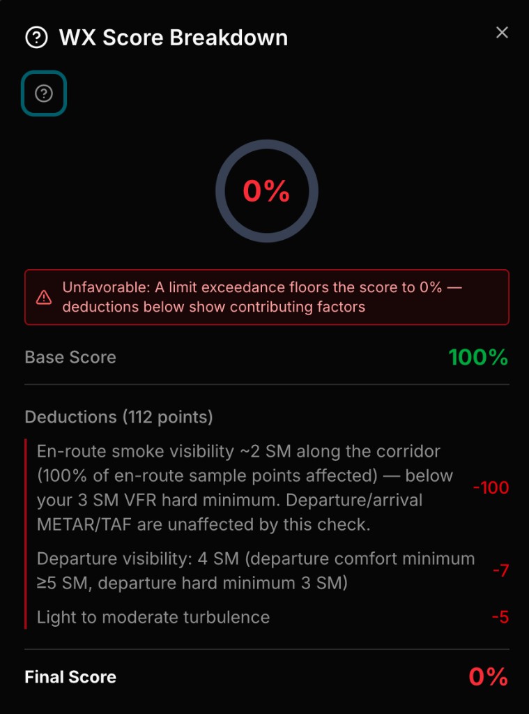
If the worst en-route estimated visibility is below your VFR visibility hard minimum, the WX Score goes to 0%. You'll see a visibility deduction in the score breakdown naming en-route smoke.
Soft minimum
If visibility is between your soft and hard limits, PlaneWX applies a caution penalty on the same soft/hard curve used for terminal visibility — not a separate smoke scale.
You need a VFR visibility hard minimum on file for smoke to produce a Unfavorable. Soft-only profiles still see the smoke overlay and narrative, but scoring is skipped until a hard limit is set in Personal Minimums.
VFR vs IFR
| Flight rules | Map & narrative | WX Score |
|---|---|---|
| VFR | Shown when smoke is active | Scored vs VFR visibility soft/hard mins (en-route only) |
| IFR | Shown when smoke is active | Informational only — no score impact from smoke alone |
Data Sources
NOAA HMS smoke plumes
Satellite-detected smoke boundaries with light / medium / heavy density. These are broad regional footprints — they can extend beyond areas with reduced surface visibility.
PM2.5 concentration
Where available, PlaneWX estimates statute-mile visibility from particulate concentration along corridor sample points. When PM2.5 is missing inside an HMS plume, density is used as a conservative visibility estimate so active smoke isn't ignored.
Smoke estimates are decision support, not a substitute for looking outside or for official weather products. Always cross-check METARs, PIREPs, and what you see from the cockpit.
Quick Checklist
- •Set VFR visibility soft and hard minimums if you fly VFR and want smoke to score.
- •On the map, click the plume and corridor markers for density and estimated visibility.
- •Open Score Breakdown — en-route smoke Unfavorables appear as a visibility deduction.
- •IFR trips: treat smoke as awareness; your score still reflects icing, turbulence, ceilings, and other hazards.